First test surveys of Vistula river levees
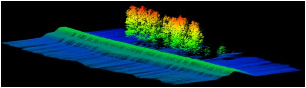
In the last week of June and the first week of July we performed first test surveys of Vistula river levees. Three kinds of surveys were conducted along the southern levee between Płock and Wyszogród. The first was the GNSS survey of levee geometry and of the ground control points used in photogrammetry postprocessing. The second dataset was acquired with MSP „Hawk Moth” UAV, equipped with a visible light camera and an ultralight laser scanner Yellowscan Mapper. The third survey was performer with an ultralight manned aircraft using light laser scanner.
This was a simulation of using a long-range, low-altitude UAV, which could be possible in the future. The important part of our test days was to try the unmanned platform and its sensors. The flights conducted were a perfect opportunity to verify our initial methodology, different sensors integration and the field workflow. The gathered data will be useful as our material to make assessment of the initial terms and data processing workflow, but also to continue our research towards SAFEDAM objectives.
